Appraw home
Register / Login
  • Set your phone/device
  • Android

    • Android Games
    • Android Apps
    • Android Themes
    • Android Keyboards
    • Live Wallpapers
    • Android Ringtones
    • APK Downloader
  • Windows

    • Windows Apps (All)
  • Downloads

    • Free Ringtones
    • Alert Tones
    • Wallpapers
  • Apple

    • iPhone Ringtones
  1. Home
  2. Free Android Apps
  3. ViewRanger GPS - Trails & Maps

ViewRanger GPS - Trails & Maps ViewRanger GPS - Trails & Maps ViewRanger GPS - Trails & Maps ViewRanger GPS - Trails & Maps ViewRanger GPS - Trails & Maps
ViewRanger GPS - Trails & Maps Icon

ViewRanger GPS - Trails & Maps

Augmentra
Rated 4.00 (16,354)
↓ 57

Description

ViewRanger is the complete offline mapping, navigation & guided trail service for Outdoor Enthusiasts.

"Google Play"- One of the Best Apps of 2013
"As seen on Channel 5’s The Gadget Show" - awarded 5G's
"The Sunday Times"- selected ViewRanger as one of their "five-star must have applications, in their guide to the best apps of the year
"T3 Magazine"- The ultimate off road GPS guide software that not only takes you places, but shows you what’s there on arrival!

FREE MAPS INCLUDED
● OpenStreetMap© & OpenCycleMap
● Bing Ariel Imagery, Ski map, Transport map
● GB Ordnance Survey 1:250.000 map for England, Wales & Scotland

Premium topographic mapping also available from Ordnance Survey and licensed mapping for many other countries.
-------------------------------
FEATURES INCLUDED
● GPS mapped location, even without mobile signal
● Offline map mode* – store in advance using “Create Saved Map???
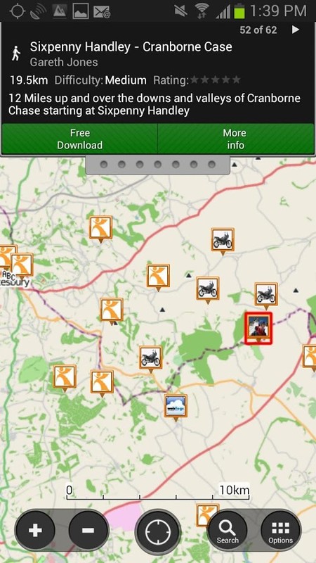
● Access to 1000's of route guides
● Track recording – view your path on map to keep or share, even add Flickr photos
● Sports computer stats – view distance, speed, etc.
● Real time location sharing** – BuddyBeacon (requires data connection)
● Active Route Navigation***
● Powersave mode in the GPS settings
● Synchronises with web account for route planning, publishing and sharing.(http://my.viewranger.com)
● Integrated with Facebook, Twitter
-------------------------------
Already a fan of ViewRanger? Like us on Facebook or Follow us on Twitter for the latest news and updates:

https://www.facebook.com/viewranger
https://www.twitter.com/viewranger

-------------------------------
Free Global open-source geographic maps are available, streamed over data connection and can be cached for offline use. Download Great Britain Ordnance Survey® Explorer 1:25,000 & Landranger 1:50,000 maps.
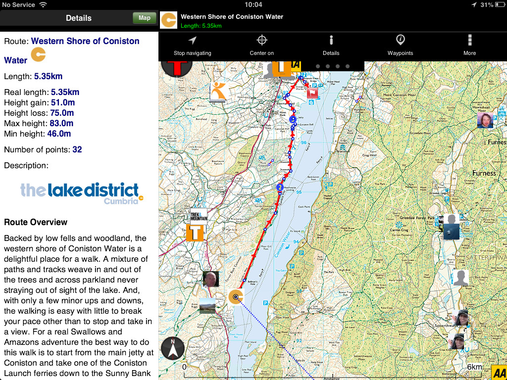
With ViewRanger, you can choose the best map to use and you'll always know your mapped location even where there’s no mobile signal.

It’s easy to record a track of your progress, so you can view your path and stats for every trip. Your tracks can be stored using your free web account (http:/my.viewranger.com) or shared using Facebook or Twitter, you can even add photos using Flickr. You can also use BuddyBeacon, our PIN protected real-time** location sharing feature as used by the Children in Need rickshaw challenge team.
Planning a trip? Use ViewRanger to create & follow your own routes or simply download one from our massive library of expert and community generated walks and cycle rides***. Our expert guided routes are created by publishers, outdoors magazines and tourist boards.

Designed for Hiking, Backpacking, Mountain Biking, Cycling, Climbing, Skiing, Snowboarding, Horse riding, Greenlaning, 4x4, Off roading, Quad biking, ballooning, Micro light flying, Paramotor, Photography and most outdoors activities. It’s used & trusted by over 100 Search & Rescue teams across Europe and the USA.
-------------------------------
Paid for Map choice available in over 22 countries:
Great Britain Ordnance Survey, Ireland (OS Ireland and OS NI), Germany (BKG), France (IGN), USA (USGS/Accuterra), Austria and Liechtenstein (Kompass), Belgium (IGN/NGI) Canada (NR Can), Czech Republic (DPA), Finland (NLS), Netherlands (Kadaster), New Zealand (LINZ), Norway (Statkart), Slovenia (NMA) Spain (CNIG), The Canaries Islands (Discovery Walking), Sweden (Lantmäteriet)), Switzerland (Swisstopo), Denmark (Geodatastyrelsen), Madeira, Greece (TERRAIN Editions SA), Slovakia, (DPA), and parts of Italy.

*store in advance using “Create Saved Map???. ** requires mobile signal. *** may incur additional charges
Free Global maps © 2012 OpenStreetMap, CC-BY-SA & contributors.
Need more info? visit: http://www.viewranger.com. Any questions or feedback, please drop us an email: [email protected]
›
Added
14th March 2014
Version
70000
File Type
APK
File Size
4.28 MB
Requires
Android 1.6 or above
Package
com.augmentra.viewranger.android
Aerial Backcountry Backpacking Bike Biking Cycle Frontcountry Gps Hike Hunting Location Map Mapping Maps Military Mountain Navigation Offline Openstreetmap Outdoor Routes Satellite Ski Skiing Snowboard Topo Track Tracker Tracking Trails

Download ViewRanger GPS - Trails & Maps 70000 APK Android App for free to your Android phone

Download ViewRanger GPS - Trails & Maps

Alternative Apps to ViewRanger GPS - Trails & Maps

  1. Waze Social GPS Maps & Traffic Icon
    Waze Social GPS Maps & Traffic
    Waze
    Avoid traffic jams, police traps, and...
    Download APK
  2. Couple Tracker -Mobile monitor Icon
    Couple Tracker -Mobile monitor
    BytePioneers s.r.o.
    Couple Tracker is BEST AFFAIR AND...
    Download APK
  3. Maverick Pro Icon
    Maverick Pro
    Code Sector
    Use offline maps and GPS even without an...
    Rated 4/5
    Download APK
  4. AppLock Icon
    AppLock
    DoMobile Lab
    Fingerprint lock only works in Android...
    Download APK
  5. Maps Icon
    Maps
    Google Inc.
    Going somewhere? Go with Maps, the...
    Rated 4/5
    Download APK
  6. GPS Route Finder Icon
    GPS Route Finder
    Prime Studio Apps
    Find easiest and fastest route for your...
    Download APK
  7. Audible for Android Icon
    Audible for Android
    Audible, Inc
    Welcome to Audible. We’re an Amazon...
    Download APK
  8. hike messenger Icon
    hike messenger
    hike limited
    Messaging made personal again. Status...
    Download APK

Recommended Android Apps

  1. hike messenger Icon
    hike messenger
    hike limited
    Messaging made personal again. Status...
    Rated 4.5/5
    Download APK
  2. MapFactor: GPS Navigation Icon
    MapFactor: GPS Navigation
    MapFactor
    FREE GPS navigation app FREE offline GPS...
    Rated 4.5/5
    Download APK
  3. GPS Navigation BE-ON-ROAD Icon
    GPS Navigation BE-ON-ROAD
    Bzing sro
    FREE GPS navigation & offline maps FREE...
    Rated 4/5
    Download APK
  4. My Tracks Icon
    My Tracks
    Google Inc.
    My Tracks records your path, speed...
    Rated 4.5/5
    Download APK
  5. Offline maps & Navigation Icon
    Offline maps & Navigation
    Navigation.
    Here we created another great navigation...
    Rated 4/5
    Download APK
  6. Scout GPS Maps, Meetup & Chat Icon
    Scout GPS Maps, Meetup & Chat
    Telenav, Inc.
    Sure, you can navigate, avoid traffic...
    Rated 4/5
    Download APK
  7. Noom CardioTrainer Icon
    Noom CardioTrainer
    Noom Inc.
    Your app for walking, running, biking &...
    Rated 4.5/5
    Download APK
  8. Glympse - Share GPS location Icon
    Glympse - Share GPS location
    Glympse
    Glympse is a fast, free and simple way to...
    Rated 4/5
    Download APK
  9. GPS Maps FullFunction Icon
    GPS Maps FullFunction
    ZappZ
    The most easy way to know where you...
    Rated 4/5
    Download APK
  10. Map My Ride GPS Cycling Riding Icon
    Map My Ride GPS Cycling Riding
    MapMyFitness, Inc.
    Map My Ride – GPS Cycling, Riding...
    Rated 4.5/5
    Download APK

ViewRanger GPS - Trails & Maps User Reviews & Comments

appraw dino


© 2025 Appraw App Store
Terms | Privacy Policy | Contact